Aleck Tan – Blog 2
June 23, 2017 – FIELD DAY
Today, I started to map plants and brush at my survey area in Enderts Beach Coastal Plain. It was challenging because I had to apply my knowledge of the vegetation to my survey after one crash course last week. It was also challenging because of the terrain and the thick heavy (and thorny) brush. Even though the survey area is bordered by a popular beach and a popular road, it feels like I am the only person around because of the vegetation that divides the survey area from the other popular areas.
I used a Trimble device and a Garmin GPS device to map individual plants and brush. I also used a field map of the area to easily draw and identify plants so I wouldn’t have to walk through harsh blackberry bushes to collect GIS data. It took longer than I would have wanted to cover a certain area because I was trying to learn how to use the Trimble device, but it was a great learning experience to figure out how I wanted to do the survey so that I can be more efficient for later field days.
June 24, 2017 – FIELD DAY
Today, I went out with a GIS specialist named Henry from the Tolowa Dee-Ni’ Nation, which is one of the Native American tribes in the area. We mapped out a large section of my study area together, in continuance of my work from yesterday. Company made the survey more enjoyable and easier since I had someone else to work with and identify plants with. The field day went by a lot faster and was much more productive than yesterday’s work. When Henry had to leave early, I was more comfortable working on my own. I was able to find my groove and keep collecting information for my survey report.
One challenge of surveying an area with heavy brush and tall grass is having to find a way to exit the study area to get back on the trail. I struggled with finding an easy access point because there was heavy brush and large thorns that I didn’t want to walk through. There was one point where I thought it would be easy to get back on the road but upon closer examination, I realized it wasn’t possible for me to walk through.
I tried to find another way, and walked/crawled through other brush, which was a mistake because it led me to heavier brush where I received the bulk of my scratches from blackberry bushes. I reviewed my maps to find easier access points, which eventually led to one. After 30 minutes of trying to leave, I was finally back on the road and walked back to my car. When I looked at the map again to see where I had exited out from, I realized that there was a clear distinct trail a couple hundred yards south, which would have come in handy. The lesson of the day is: be very familiar with field maps and your study area.

Smith River swimming hole off of Walker Road.
June 25, 2017 – JEDEDIAH SMITH STATE PARK
Today, I explored Jedediah Smith State Park with my neighbors from my park housing. We planned on going on the first ranger-led kayak tour on the river but didn’t get a chance to make reservations beforehand. When we arrived at the Hiouchi Visitor’s Center, we found out the kayak tours were all booked up for the day. We reserved our spaces for next weekend instead. After, we went to a swimming hole nearby that is on state park land and set up right on the gravel by the river. The river was cold, but refreshing. The day was perfect though because it was sunny and warm.
Afterwards, we drove on Howland Hill Road in Hiouchi, which is a popular dirt road that people drive on. The dirt road has plenty of pot holes to avoid and there is often only enough room for one car to pass. The road takes you through massive old growth redwoods, and leads to numerous trails, one of which we visited called Stout Grove. It was a short hike that allows you to get up close and personal with redwoods. I found out that when you touch a redwood, it’s a bit squishy and soft. It’s always humbling to just walk amongst them. The trail also leads to the Smith River, where people can enjoy swimming and kayaking.
Smith River swimming hole off of Walker Road.
June 29, 2017 – BALD HILLS
My supervisor Michael Peterson and I checked out the Bald Hills today. It was incredibly beautiful and interesting because the hills are covered in prairie/grasslands, very different than the redwood forests that the area is famous for. We looked at old wagon roads that were used before, and checked out an old cabin that seemed to be in the middle of nowhere.
We enjoyed lunch at a fire lookout station, where there was a fire crew that was mowing the grass around the lookout station to create a fire break. One of the fire supervisors James brought us into the station and showed us how to use a fire finder.

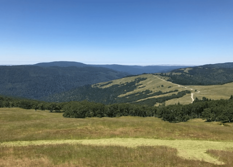
Bald Hills and the Bald Hills Road. You can see the fire break around the lookout tower. If you look at the horizon, you might be able to see the ocean amidst the fog.

Fire finder at the lookout tower. You peek through the hole in the gold-colored ruler to locate the fire and to measure where and how far the fire is. Back in the day, the location had to be exact as fire crews had to ride horses to get to the fires. Nowadays, they only use the range finder for a general location of the fire. If there are fires, they send out a helicopter crew to pinpoint the exact location of the finder.

Sunlight shines through the fog and trees
July 1, 2017 – JEDEDIAH SMITH STATE PARK
Today, my friends and I traveled to Jedediah Smith State Park in Crescent City, California to go on the ranger-led kayak tours on the Smith River. The Smith River is California’s only undammed river and is considered to be a Wild and Scenic River. People can catch a variety of fish in the river, including Chinook salmon, steelhead and rainbow trout. The Smith River is also where we went swimming last Saturday.
We parked at the Jedediah Smith Campground day use area and met our kayak ranger named Brad, who was very knowledgeable and easy-going. The tour started with a .5-mile hike to the kayaks that were stationed upstream of the day use area. Brad talked about the logging industry, the river and the redwoods in the surrounding area.
When we reached the kayaks, we hopped on with our personal flotation devices and helmets. We went upstream and checked out the Stout Grove from the river, and then floated downstream about ¾ miles down the river. It was a very relaxing but also exciting day. We went through a Class I rapid, and also a Class II rapid. The Class II rapid was where I got drenched as the kayak dunked into a deep section of the river, but that was the best part of the kayak tour.
After the kayak tour, we enjoyed lunch in the day use area. Then, we went on a short hike on the Leiffer Trail loop. It was about a mile or so long, so it was easy and wasn’t crowded at all like many trails in Redwood National Park. I found a ton of redwood sorrels at the base of the redwoods, which I loved.

Redwood sorrel that grows in the understory of redwoods.

Ranger-led kayak tour on the Smith River.