
MAPPING, IRON, AND GEESE – BUT NOT AT THE SAME TIME
I am still here, mapping Baker-Biddle, but do not worry. The end is in sight! I finished the existing condition mapping for the Baker-Biddle site this week and just in time to begin a planting design project with Saugus Iron Works! This week honestly had everything: site visits, webinars, AutoCAD mapping, Adobe Illustrator editing, visits to the Charlestown Navy Yard, and a visit to a landscape architecture firm.

A strawberry patch just off the nature trail; it will provide divisions to be planted along the stream.
To give a short introduction – and for the full story, please refer to Ella – Saugus Iron Works National Historic Site is a restored industrial landscape and visitor center retelling its manufacturing history from the 17th century. Truly the birthplace of the industry in America! The factory harnessed the power of the river and sits in a small valley. Visitors descend into the valley, and the town seems to disappear. It is a very introspective site. The forge and ironworks provide demonstrations occasionally, and pathways lead you throughout the site. The garden around the visitor center and the entrance are beautifully maintained, and as one gets closer to the river, the aesthetic shifts into a more natural setting.
A week before heading over to visit Saugus, I joined a phone discussion about the Branching Out project there in August and the need for a planting plan. The team is tackling the eastern riparian buffer between a stone wall and the pathway. Currently the grassy slope keeps erosion at bay, but attracts the local hordes of geese. (During our site visit, we saw plenty of them and their mess.) The planting design for the 230 feet of streamside needs to balance erosion protection, goose deterrence, and all without interrupting views from across the river. Another goal of the project is to use locally sourced and native vegetation.

We measured the stone wall, distance perpendicular to the path, and determined the width of the planting bed.
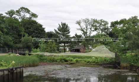
Ella, Chris, and I (from the Olmsted Center) met up with the Saugus team, who gave us a tour of the house, visitor center, and site. Unfortunately, the rain made for a soggy, gray day. The site for the Branching Out planting measures approximately 5 by 150 feet. We determined that there will be four planting zone types within that space. The northernmost zone will need to be low growing herbaceous perennials and woody shrubs in order to maintain a view to the wayfinding signs and workshop. The next zone can have medium shrubs in the mix, and the third zone can accommodate small trees. The fourth and final zone is the most constrained; it is a 33 foot long segment directly between the path and the rock wall, which means that it measures less than 4 feet wide.
Although the planting design is not formal, consideration needs to be taken to ensure that it will be easy to maintain in the future. Design is not just about creating an aesthetically pleasing setting; the design must be practical and feasible.
Planting Zones: This is the view of the stream-side, looking east from the wooden dock. The different planting zones react to the physical and visual limitations of the site.
We also had the opportunity during our visit to explore the collection of artifacts from the site. You will never see another group of people so excited about old wood!
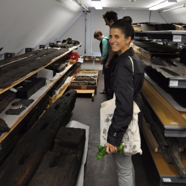
Taking a tour of what remains from past structures at Saugus.
So long for now,
Jill