What’s Beneath Your Feet: Considering the archaeology of your park
By: Maeve Marino
Do you ever go hiking out in your National, State, or Metro parks? If you do then you’re probably surrounded by archaeology, sometimes directly beneath you. Now some of you may be thinking “well, duh” but not a lot of parks highlight their archaeology and many people will have no idea that where they are standing was once a campsite or village of indigenous people, or even that later a European immigrant built a cabin in that now empty field. Take the photos below for example, you can see the river and trees and a wide-open field. Nothing looks out of the ordinary, but what I know is that there was once a Whittlesey farming village there sometime between A.D. 1250 and A.D. 1450. These are the types of things archaeologists and historians learn, and we should always share some of that knowledge, otherwise what’s the point of having it? So here is your reminder to share the knowledge you have about your park, it’s much more fun than keeping it to yourself!


Cuyahoga National Park
The archaeology of my park is, in essence, my entire purpose this summer. So, these past few weeks I have been hiking through the park occasionally to visit sites that look just like those photos above. Some have been through thick berry briars, some in pleasant fields, and others in shady wooded areas, you just never know until you get there what type of day it’ll be.
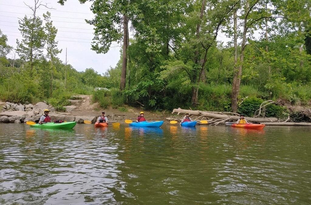
Another way I’ve been considering my parks archaeology is from the river, via kayak. This is important in our park because as the river moves it can often expose archaeological features in the banks. Due to the rate of erosion of the banks of the river, we need to monitor the banks regularly to be able to quickly record and mitigate any feature that erodes out, before it is completely destroyed by erosion and river movement. In the first photo below is a group of us that went out on the river, an interdisciplinary team made up of biologists, interpretation rangers, and of course me (in the center), an archaeologist. Working with a team such as this has a lot of advantages, I can teach them what to keep an eye out for while out on the river and they can also teach me about the plants and river conditions. In the second river picture below you can see us stopped on a sandbar discussing the river and on the far right can see an example of the exposed riverbanks.

Interdisciplinary team monitoring the river banks

Example of exposed river bank (far right)
If it hasn’t become obvious yet from my previous blog posts, I’m a big advocate of inter- and multi-disciplinary teams, which I was able to be part of on another day as well. I joined some of the natural resource management team on a fun project- electroshock fishing. We were evaluating a potential cold-water stream in an old golf course. To evaluate the stream, we needed to do fish counts. The person in the front of the photo is wearing an electroshocking backpack which sends out electricity into the water that stuns fish. Once the fish are stunned, we use the nets to catch them and place them into buckets.

Electroshock fishing in order to do fish counts
These buckets are then used to sort the fish by species and then counted. The photo below shows all the buckets full of the different species of fish we found, including catfish, sunfish, dace, and many, many others. The fish were then put back into the stream after they were counted. This was a great way to spend the day, doing something completely out of my comfort zone (I actually hate touching fish, and this required a lot of fish touching) and outside of my professional abilities and knowledge. I firmly believe we should all be uncomfortable sometimes, it’s how we grow and gain understanding, and this was a great opportunity for me to be a bit uncomfortable and learn a lot about natural resources!

Fish separated into different buckets by species